Spalding Allsky Camera Network
ACCEPTING TAX-DEDUCTIBLE DONATIONS TO BETTER SERVE THE COMMUNITY
-- DONATE HERE
-->Use the "Imagery" tab above to search for events by location (last 30: days: if you need older data or feel the current dataset is incomplete, please email: dfree@spalding-allsky.net)
FIREBALL: a brilliant meteor that may trail bright sparks
BOLIDE: a large meteor (FIREBALL) especially one that explodes
Events of Interest
------ Large Bolide (5kt) over CARIBBEAN (GLM,USG,CTBTO) NOTE: this impact was predicted (see NEO NEWS below)
Publications
-- NEO NEWS: International Asteroid Warning Network (IAWN.net)-- "Asteroid 2019 MO: The Latest Confirmed Small Impactor"
-- Publication: "The Creston, California Meteorite Fall and the Origin of L Chondrites" support data from the Spalding Allsky Camera Network
-- Publication: GOES Satellite, Geostationary Lightning Mapper (GLM) Fireball Detections Correlated with the Spalding Allsky Camera Network
-------------------- Video: GLM/Allsky Detection of the 12 Feb Bolide near Florida (both 16 and 17)
-------------------- Video: GLM Detection of the 1 Feb Bolide over Cuba (both 16 and 17)
-------------------- Cuba Bolide also Reported by JPL as 1.4kt Total Impact Energy at 23.7km altitude
-- Video: Large, Fragmenting Bolide over British Columbia, 5 Sep, Recorded by COTR, Cranbrook (Node 28), also Reported to JPL Fireball Network at 0.13kt total impact energy (Click on Fireball Map for Details)
-- Video: Large Bolide over Arizona, 2016
-------------------- Publication: Analysis of the June 2, 2016 bolide event over Arizona
-------------------- Publication: Orbit and origin of the LL7 chondrite Dishchii'bikoh (Arizona)
-- Video: SpaceX's Tesla Does Burnout on Hohmann Road to Asteroid Belt!
-- Video: Fantastic Auroral Display over British Columbia!
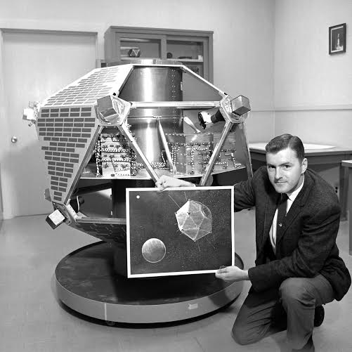 DICK SPALDING: CREATOR OF THE DoD SYSTEM THAT FEEDS BOLIDE DATA TO JPL. CLICK PICTURE FOR LINK TO THE RICHARD E. SPALDING FOUNDATION WEBSITE
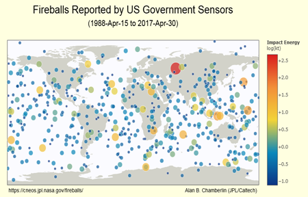
  --Click on the Fireballs Map Below for JPL Bolide Reports-- NOTE: BOLIDE LIGHT CURVES NOW AVAILABLE ON THE JPL WEBSITE
 ----- GEOSTATIONARY LIGHTNING MAPPER (GLM) BOLIDE DETECTIONS WEBSITE
----- GLM DETECTION OF FALCON 9 ROCKET DESTRUCTION ON ABORT
-------------------- VIDEO
 -- List of Current, Global Events Seen by Ground Observers
 -- STREWNIFY: Local Coverage of Events for Meteorite Recovery (Trajectories, Impact Points)
 -- Center for Orbital and Reentry Debris Studies: Reentry Predictions
-------------------- Video: Russian Rocket Body Reentry Over US
------ Cameras for Allsky Meteor Surveillance (CAMS) - SETI Institute
 ----- CAMS FLORIDA WEBSITE (pick a date to view)
 --------- NASA’s All Sky Fireball Network (ASGARD) ------
 ------- Daily Predictions of Brighter Satellite Overflights ------
-------------------- Video: STARLINK CONSTELLATION OVERFLIGHT, NEW MEXICO ---------
--Click on the Fireballs Map Below for JPL Bolide Reports--
Mr. Richard E. Spalding developed the Allsky Camera System to monitor, track, and analyze Transient Luminous Events (TLE), including meteors, Sprites, Jets, etc., in order to provide "ground-truth" to assist both Science (NASA) and Treaty Monitoring (CTBTO) operations in confirming the impact of Large Meteors (bolides) in Earth's atmosphere and support the refinement of energy (based on size and velocity) and trajectory calculations.
The program objectives include: 1) field a network of uplooking, wide-angle view cameras at a number of sites throughout the continental United States and other countries, 2) develop the network to access/archive data and make the data available for processing and analysis by interested parties, 3) develop software tools for calibration, removal of detector effects and anomalies, automatic event detection and correlation among stations, and automatic trajectory computation, and 4) develop a companion, high-dynamic rang Radiometer to improve the diagnostic capability of the Spalding Allsky Camera Network.
Node Locations
-- Node Number/Name/Location Spreadsheet
|
Current StatusSpalding Allsky Cameras are located throughout the world. Locations can be viewed by using the provided map. The status of each node is color coded below the map. Viewing ImageryEach node continuously watches the sky and captures video by detecting motion and light intensity. By clicking on the appropriate node pushpin on the map, you can view past events through the node viewer via the link provided. The circle for the online nodes indicates the approximate coverage area for that node. The Imagery Tab provides a list of cluster events where two, or more, nodes detected the same event. You can download a cluster event, or individual events via the node viewer, from the Imagery Tab. We keep a permanent archive of all event data uploaded to SkySentinel. Most Nodes also keep a long term archive of their data. So, If you don't see an event you are looking for, or are looking for data that is over 30 days old, please contact us at (321 505-1060) |
