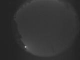
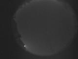
WSentinel capture software creates 3 primary event files; composite jpg, video(.mp4), and a spreadsheet(.csv) which contains a timehistory of energy, azimuth/elevation, and pixel mapping for the event as seen from the camera location: (see Spreadsheet Column Definitions here).
NOTE: The az/el data in the spreadsheet are approximations and offline calibration is required for refined assessments. Refined calibrations require use of the nightly composites which are available via the link on the right side of this page.
If you don't see an event, or you are looking for data over 30 days old, please contact us at: 
Node Events (last 30 days)
|
|
Date: July 13 2025
Time: 18:18:56.815 UTC
|
Date: July 13 2025
Time: 18:18:23.454 UTC
|

Date: July 13 2025
Time: 18:17:49.750 UTC
|
Date: July 13 2025
Time: 06:47:13.806 UTC
|
Date: July 13 2025
Time: 06:47:09.745 UTC
|

Date: July 13 2025
Time: 03:23:19.785 UTC
|
Date: July 12 2025
Time: 22:04:45.485 UTC
|

Date: July 12 2025
Time: 22:04:10.424 UTC
|

Date: July 12 2025
Time: 22:03:29.977 UTC
|
Date: July 12 2025
Time: 21:45:13.267 UTC
|
Date: July 12 2025
Time: 21:39:44.711 UTC
|

Date: July 12 2025
Time: 21:37:47.841 UTC
|
Date: July 12 2025
Time: 21:37:13.745 UTC
|
Date: July 12 2025
Time: 21:36:40.124 UTC
|

Date: July 12 2025
Time: 21:36:06.441 UTC
|

Date: July 12 2025
Time: 21:35:32.936 UTC
|

Date: July 12 2025
Time: 21:34:59.414 UTC
|

Date: July 12 2025
Time: 21:34:25.867 UTC
|

Date: July 12 2025
Time: 20:55:56.469 UTC
|
Date: July 12 2025
Time: 20:50:22.288 UTC
|
|
