WSentinel capture software creates 3 primary event files; composite jpg, video(.mp4), and a spreadsheet(.csv) which contains a timehistory of energy, azimuth/elevation, and pixel mapping for the event as seen from the camera location: (see Spreadsheet Column Definitions here).
NOTE: The az/el data in the spreadsheet are approximations and offline calibration is required for refined assessments. Refined calibrations require use of the nightly composites which are available via the link on the right side of this page.
If you don't see an event, or you are looking for data over 10 days old, please contact us at: 
Node Events (last 30 days)
|
|
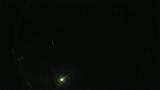
Date: August 1 2026
Time: 08:41:15.972 UTC
|
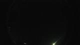
Date: July 29 2026
Time: 09:57:12.531 UTC
|
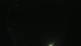
Date: July 29 2026
Time: 09:22:12.382 UTC
|

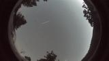
Date: July 29 2026
Time: 07:48:57.444 UTC
|

Date: July 28 2026
Time: 11:31:24.285 UTC
|

Date: July 26 2026
Time: 10:52:12.555 UTC
|

Date: July 25 2026
Time: 10:48:35.859 UTC
|
Date: July 23 2026
Time: 03:53:39.57 UTC
|

Date: July 20 2026
Time: 08:46:09.690 UTC
|

Date: July 12 2026
Time: 05:30:21.724 UTC
|
Date: July 7 2026
Time: 10:19:38.950 UTC
|

Date: June 29 2026
Time: 05:53:03.222 UTC
|
|
